
Looking for accurate, reliable, and professional survey services? Let Geo Informatic help you build with confidence. From GPS and Total Station surveys to pipeline and alignment solutions, our expert team is ready to support your next project—no matter the size or location.
Geo Informatic specializes in comprehensive Topographical Survey Services, integrating advanced methods such as alignment surveys, as-built surveys, and Total Station surveys to deliver precise and reliable measurements for construction, infrastructure, and oil & gas projects.
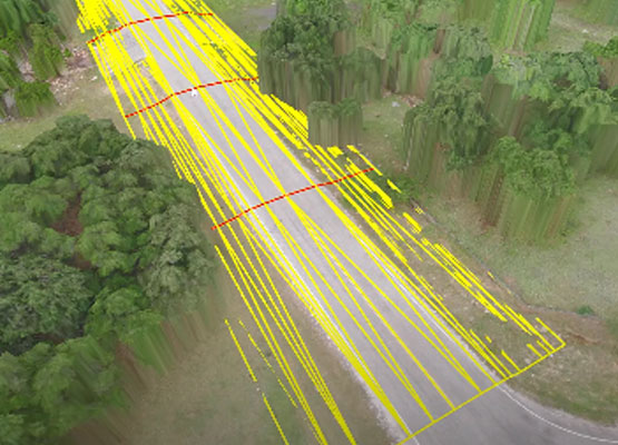
As a trusted name in the industry, Geo Informatic Survey Services leads the field with expertise in Total Station Surveying, 3D Laser Scanning, and LiDAR Technology, ensuring high-resolution data capture and exceptional accuracy across a wide range of applications.
In sectors such as marine, oil & gas, and power generation, topographic surveys are essential for verifying a site’s as-built conditions, elevations, and structural positioning. These surveys support effective decision-making and risk reduction during planning and execution.

At Geo Informatic, we offer high-precision Total Station Survey services to support construction, engineering, and land development projects. Using state-of-the-art Total Station instruments from top brands like Leica and Topcon, we capture accurate distance, angle, and elevation data that form the foundation of reliable project planning and execution. Our team of trained surveyors ensures every measurement is precise and aligned with your project’s technical requirements.
Whether you’re mapping terrain for topographic analysis, laying out structures on a construction site, or calculating earthwork volumes, our Total Station Surveys deliver exceptional detail and clarity. We specialize in boundary marking, construction layout, as-built surveys, and infrastructure documentation with a focus on speed, accuracy, and efficiency.
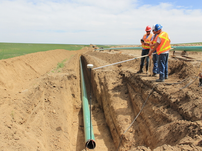
Geo Informatic offers specialized Pipeline Survey services designed to support the safe, efficient, and accurate planning and installation of underground and above-ground pipelines. Our team uses advanced surveying instruments—including Total Stations, GPS, and GIS tools—to map precise alignments, elevations, and terrain profiles across diverse landscapes. From oil and gas pipelines to water, sewer, and utility lines, we deliver the geospatial accuracy that pipeline projects demand.
Our services cover every stage of pipeline development: route selection, centerline marking, right-of-way mapping, topographic profiling, and as-built documentation. By integrating survey data with GIS and CAD platforms, we ensure that pipeline designs are built on a strong foundation of field-verified measurements and ground conditions. We also assist in identifying potential obstacles such as elevation changes, road crossings, or environmental features that may impact routing or construction.
Geo Informatic provides professional Alignment Survey services to ensure precise positioning and layout for linear infrastructure projects such as roads, railways, pipelines, transmission lines, and bridges. Using advanced Total Stations, GPS systems, and digital mapping tools, we help define and maintain accurate horizontal and vertical alignments throughout the construction process.
Our alignment surveys are critical for setting out centerlines, offsets, and elevation profiles with millimeter-level precision. We work closely with engineers and construction teams to establish accurate reference points, monitor structural shifts, and ensure that built elements follow the intended design path without deviation. Whether it’s a highway curve, railway gradient, or a long-distance pipeline, alignment accuracy directly affects project integrity and safety.
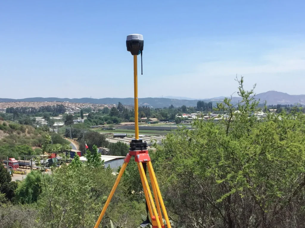
Geo Informatic delivers high-accuracy GPS Survey services to support a wide range of geospatial, engineering, and construction projects. Using advanced Global Positioning System (GPS) and GNSS (Global Navigation Satellite System) technology, we provide fast, reliable, and cost-effective positioning solutions for both large-scale and site-specific surveys.
Our GPS surveys are ideal for topographic mapping, land boundary definition, utility mapping, route alignment, and control point establishment. We use Real-Time Kinematic (RTK) and Post-Processed Kinematic (PPK) techniques to achieve centimeter-level accuracy, even in challenging terrains like those found in Gilgit-Baltistan and other remote regions.
We help several industries with our expert Gis Services
For site layout, leveling, structure alignment, and as-built surveys that ensure quality and compliance.
Road, railway, and bridge projects rely on our alignment and topographic surveys for smooth project execution.

Precision route alignment, right-of-way mapping, and GPS-based monitoring for safe and efficient pipeline development.
From boundary surveys to subdivision planning, we assist developers, architects, and planners in maximizing land potential.
1
We begin by understanding your project scope, goals, and technical requirements.
2
Using advanced Total Stations, GPS/GNSS, and other geospatial tools, we collect accurate data on-site.
3
We process the raw data using CAD, GIS, and modeling software to generate detailed maps, drawings, and reports tailored to your needs.
4
We deliver clear, well-organized output, including topographic maps, AutoCAD files, and survey reports—ready for use in planning, design, or construction.
Trust Geo Informatic for expert GPS, Total Station, pipeline, and alignment surveys—delivered on time, with precision.