Many industries depend on satellite imagery for infrastructure planning and environmental monitoring tasks. But getting the correct data and making sense of it can take time, effort, and specialised skills. Traditional methods often fall short, leading to delays, low accuracy, and incomplete results.
When project teams can’t access reliable data on time, it causes confusion, slows progress, and affects outcomes.
We Geo Informatic simplify the process by delivering accurate, ready-to-use satellite data, helping you work faster, reduce risks, and make confident decisions that drive growth and support communities.
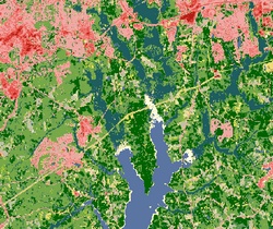
Land Use / Land Cover (LULC) Mapping is one of the foundational applications of remote sensing, enabling the classification of natural and man-made features on the Earth’s surface. At Geo Informatic, we use high-resolution multispectral satellite imagery to map urban areas, vegetation, water bodies, barren land, agricultural zones, and more. These classifications are critical for environmental monitoring, regional planning, and sustainable land management.
Our team processes and analyzes data from sources such as Landsat, Sentinel, and SPOT satellites using supervised and unsupervised classification techniques in GIS platforms. By interpreting spectral signatures and reflectance patterns, we generate accurate and up-to-date LULC maps customized to client needs.
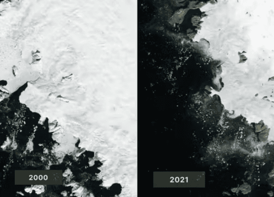
Change Detection is a critical remote sensing application that allows stakeholders to identify, quantify, and monitor physical changes in the environment over time. At Geo Informatic, we use multi-temporal satellite imagery to detect land degradation, urban sprawl, deforestation, wetland loss, glacial retreat, and more.
We employ image differencing, post-classification comparison, and NDVI change detection methods to deliver high-accuracy results. These insights help in environmental impact assessments, conservation planning, and long-term land management strategies. We support projects with customized reports, thematic maps, and statistical change matrices.
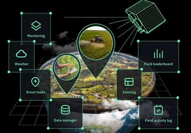
Geo Informatic offers advanced satellite-based agricultural monitoring solutions that enhance decision-making in crop production and farm management. Using multispectral and hyperspectral satellite imagery, we assess vegetation health, crop stress, pest outbreaks, irrigation needs, and planting success.
We utilize vegetation indices such as NDVI (Normalized Difference Vegetation Index), SAVI, and EVI to generate field-level insights. These tools empower government agencies, agronomists, and large-scale farm managers to track crop conditions, optimize inputs, and estimate yields at regional or national scales.
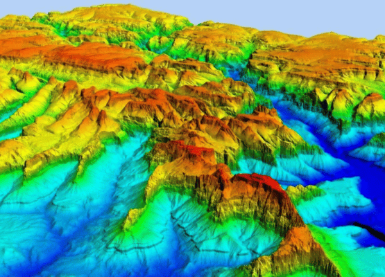
Topographic mapping is crucial for planning, design, and risk assessment in infrastructure and environmental projects. Geo Informatic creates accurate Digital Elevation Models (DEMs) and Digital Surface Models (DSMs) using satellite imagery, stereo photogrammetry, or radar data such as SRTM and ALOS.
These elevation models provide valuable insights into terrain features such as slopes, ridges, valleys, drainage paths, and surface roughness. They are widely used for flood modeling, watershed management, road alignment, and infrastructure layout design.
Our topographic datasets are processed in GIS and remote sensing platforms, and delivered in standard formats like GeoTIFF or CAD layers. With Geo Informatic, clients gain access to high-resolution, elevation-based terrain analysis that enhances project efficiency and minimizes design errors.
We help several industries with our expert Gis Services
From road networks to bridges and utilities, we lay the foundation for successful project execution.
We provide municipal authorities with accurate data for infrastructure upgrades, smart city planning, and disaster resilience mapping.
We assist companies during exploration, pipeline laying, asset mapping, and environmental impact assessments.
Our data helps organizations manage protected areas, monitor natural resources, and study the effects of climate change on ecosystems.
1
We begin with a detailed consultation to understand your project goals, site conditions, and technical requirements.
2
Our experienced field teams use advanced technologies like Total Station, GPS, UAVs, and remote sensing satellites to collect accurate, real-time geospatial data from the field.
3
We perform detailed analysis, georeferencing, digitization, and modeling to transform raw data into actionable insights and visual maps.
4
Our support doesn’t end with delivery. We’re available for revisions, clarifications, and follow-up surveys to ensure your project stays on track.
You will find us right by your side as we ensure that the obtained data seamlessly aligns with your specific requirements.