Since our formation in 2018, Geo informatics has undertaken many GIS projects in a variety of sectors, including consultancy, development and support projects. These have ranged from small one-off analysis or map production exercises through to full enterprise-wide GIS implementations.
During this time, we have worked with customers in both the private and public sector to deliver successful GIS projects. We have worked closely with internal teams and alongside other consultants, software and service suppliers and data providers.
With our extensive GIS domain experience, we can add value to any project with a locational, GIS or mapping element. We are comfortable with working to tight deadlines and can work closely with you to define the requirements and project deliverables.
Feel free to explore some of our projects below.

Detailed cadastral mapping and surveying of the 27 CDA sectors, capturing essential geographic and property-related information

Geo Informatic collaborated with Asian Consulting Engineers (Pvt) Ltd. to digitize Bahawalpur Division

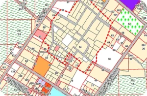
Geo Informatic successfully executed a large-scale GIS project focused on the generation of digital Masavies

Conducted change detection analysis in undeveloped sectors by comparing satellite imagery from 2007 and 2020
At Geo Informatic, we are proud to be officially certified by the Survey of Pakistan, the national mapping and surveying authority. This certification is a testament to our commitment to delivering accurate, reliable, and government-compliant geospatial services. It confirms that our methods, tools, and technical standards meet the rigorous benchmarks set by the country’s top cartographic and surveying body.

If you are interested in any of our products or services, contact us today and we will be happy to discuss your requirements.