
Using outdated maps or missing proper georeferencing and digitisation makes it hard to trust the data you’re working with. This creates serious issues when planning new projects or managing resources.
Without accurate and up-to-date data, projects can face delays, exceed budgets, or fail to meet expectations. Teams may struggle with poor planning, wasted time, and missed deadlines, leading to financial losses and a damaged reputation.
When trust in the data is lost, confidence in the project suffers too. Over time, this can hold businesses back and stop them from taking on new opportunities.
Stay ahead with accurate, digitised data you can trust. Let us GIS Navigator help you fix gaps, reduce delays, and confidently move your projects forward.
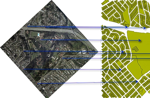
Geo Informatic provides accurate and reliable Georeferencing Services to align historical maps, scanned drawings, satellite images, and aerial photographs with real-world coordinates. By assigning spatial reference systems to non-georeferenced raster images, we make them compatible with modern GIS and CAD platforms—enabling spatial analysis, map overlay, and precise data integration.
Georeferencing is essential for projects that involve legacy data, cadastral records, land use mapping, or environmental monitoring. Our team uses industry-standard tools and control points (GCPs) to transform distorted or unreferenced maps into spatially accurate datasets that match your project’s coordinate system and scale.
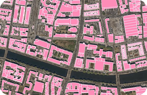
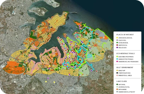
Geo Informatic offers precise and scalable Map Digitization Services to convert physical or scanned maps into editable digital formats. We specialize in the digitization of critical geographic features such as roads, rivers, land boundaries, utility networks, and elevation contours, helping you transform static maps into GIS-ready vector data for analysis and planning.
Our expert team traces and classifies features from raster images or paper maps using industry-standard software like ArcGIS and AutoCAD. Each layer—whether it’s a transportation network, water body, or administrative boundary—is accurately digitized and geospatially referenced, ensuring alignment with your project’s coordinate system and data standards.
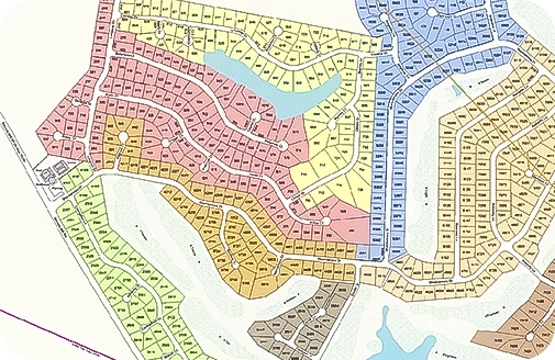
Using a combination of Total Station and GPS survey data, satellite imagery, and existing land records, we create detailed cadastral maps that are aligned to recognized coordinate systems. These maps are fully digitized and GIS-ready, making them easy to update, analyze, and share across land management platforms.
Cadastral maps are critical for land registration, taxation, urban planning, boundary dispute resolution, and infrastructure planning. Whether you’re a government agency modernizing land records, a real estate developer subdividing plots, or a municipality managing land ownership data, Geo Informatic delivers accurate and up-to-date maps tailored to your jurisdiction’s legal and technical standards.
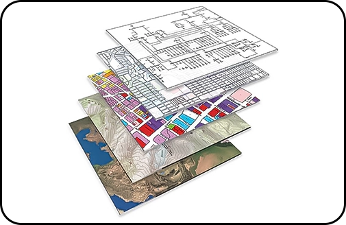
Our team integrates spatial and non-spatial data into GIS platforms, ensuring seamless alignment of topographic features, infrastructure assets, utility networks, and administrative boundaries. Whether you’re managing large-scale infrastructure projects or environmental monitoring programs, we ensure that all datasets work together in a cohesive digital environment.
We support formats such as shapefiles, GeoTIFFs, KML/KMZ, AutoCAD (DWG/DXF), CSVs, and more—tailoring the final outputs to meet your project’s specific platform (ArcGIS, QGIS, AutoCAD, etc.) and coordinate system. Our services are ideal for urban planning, utility management, environmental modeling, land information systems, and asset tracking.
We help several industries with our expert Gis Services
By partnering with Geo informatic for georeferencing and digitization, you will get to optimise resource exploration and environmental monitoring.
Our teams help enhance property management and urban planning by offering accurate and detailed cadastral maps and georeferenced data to our partners.
we will guide you on how to efficiently map utility networks and plan expansions after considering the needs & demands.
We specialise in planning smarter cities that prove to be highly sustainable for businesses and communities.