Stop struggling with unclear property data. Use reliable cadastral mapping to get the job done right, avoid disputes, speed up approvals, and make confident land decisions from day one.
When land records are unclear or boundaries don’t match, it becomes hard to manage property or plan new projects. Mistakes in cadastral maps can lead to disputes, delays, and even financial loss.
If people don’t have accurate land data, they can’t make the right decisions. This affects everything from land use planning to project approvals.
Clear and correct cadastral maps help avoid these problems. They make it easier to manage land, follow local rules, and confidently move projects forward.
Stop struggling with unclear property data. Use reliable cadastral mapping to get the job done right, avoid disputes, speed up approvals, and make confident land decisions from day one.
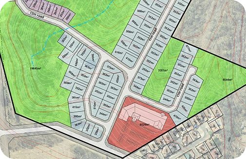
We assist in developing highly detailed maps that accurately define land parcels. This empowers stakeholders in efficient property management. Our parcel mapping services not only help minimise the risks of costly boundary disputes but also simplify the process of land management, enabling you to make sustainable decisions. With accurate boundary definitions and our continued support, you can witness long-term growth.

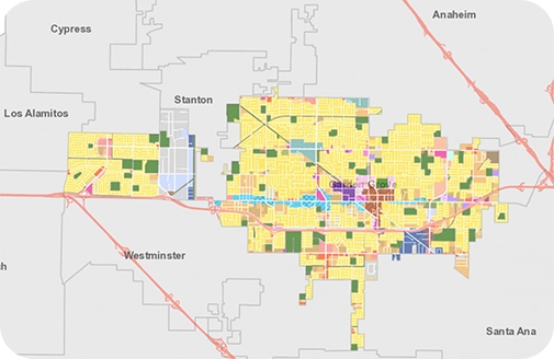
At GEO Informatic, we deliver a comprehensive view of land ownership that also includes gaining knowledge on the parcel owners. Our ownership mapping services enable our valued clients to track property details by streamlining the process of land management. GEO Informatic also facilitates the process of strategic and efficient decision-making that will be beneficial for the planners and communities alike.

We help several industries with our expert Gis Services
Geo Informatic provides advanced GIS solutions to optimize transport networks, monitor fleet movements, and improve delivery efficiency.
Geo Informatic supports law firms, landowners, and government bodies in resolving land conflicts through boundary mapping, and property overlays.

At Geo Informatic, we empower real estate developers, planners, and local governments with location-based tools to make investment decisions.
We offer tailored solutions such as vegetation analysis, improving agricultural productivity, monitoring environmental factors & climate pattern studies.
1
Once we have discussed your cadastral mapping needs, we will develop a bespoke plan to help you meet your goals.
2
Our expert team members are ready to assist you with mapping parcels, visualising boundaries and performing zoning compliance.
3
Get your hands on comprehensive cadastral mapping and enjoy ongoing support from our teams throughout a project’s lifecycle.
4
We sign a cooperation agreement and NDA, after which our team gets to work.
what makes us different
Not only the selection of state-of-the-art tools but also the human pool that has experience in managing the most complex GIS requirements
We use modern surveying tools like Total Stations, GNSS, RTK GPS, drones, and GIS software to ensure accurate, high-resolution cadastral data
Our cadastral maps are prepared in accordance with local land administration laws and can be used for official registrations.
We don’t just map — we digitize, georeference, and deliver your cadastral data in GIS-compatible formats (Shapefiles, GeoJSON, KML, etc.)
From individual landowners to large-scale municipal projects, we tailor each mapping project to your specific needs, land type, and documentation requirements.
At Geo Informatics, we value transparency, clear communication, and timely delivery. You'll receive regular progress updates and precise deliverables
Our experts are ready to guide you in finding the perfect GIS solutions for your needs. Let’s discuss your project today