
At Geo-Informatic, we specialize in delivering high-quality spatial data services, GIS consulting, and 3D modeling to support smarter decision-making and efficient project execution.
Get Free Quote today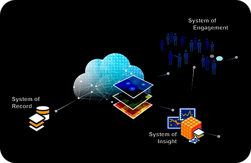
Our team of experts specialises in integrating data from multiple sources such as satellite imagery, GIS databases and sensors that operate in real time. By leveraging cutting-edge technology and modern tools, we enable our clients to visualise and analyse vast amounts of raw data and uncover trends and relationships among them. This practice allows for informed decision-making resulting in the development of sustainable infrastructures.
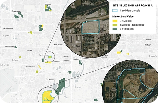
Our precise Site Selection Analysis utilises spatial data to assess various key factors such as demographics, accessibility and environmental impacts. By offering detailed and accurate reports on site selection, we enable our valued clients to select the most optimal locations and proceed with the planning and development of projects. Our strategic approach allows for minimising potential risks while increasing business potential.
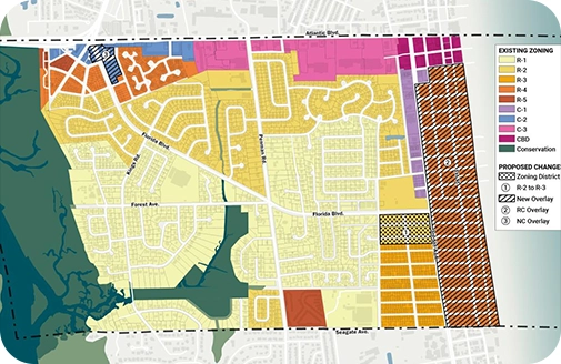
Understanding laws regarding land use and zoning is crucial for any planning and development project. At GIS Navigator, we conduct detailed Land Use & Zoning Analysis to perform various actions such as evaluating existing regulations, accessing compliance and identifying development opportunities. We empower our clients to navigate complex regulations, ensuring their development projects are workable and sustainable at the same time.
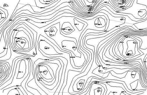
Geo-Informatic Contour Mapping services facilitate creating detailed topographical representations of the land. We generate comprehensive contour maps after analysing elevation data. These maps share information such as landforms, drainage patterns and more. Having detailed insights on the mentioned aspects facilitates urban planning, planning and development of construction projects. At GIS Navigator, we empower our clients for smart decision-making while enabling them to minimise potential risks
Geo Informatic provides advanced GIS solutions to optimize transport networks, monitor fleet movements, and improve delivery efficiency.
Geo Informatic supports law firms, landowners, and government bodies in resolving land conflicts through boundary mapping, and property overlays.
Our services include infrastructure mapping, outage management systems, vegetation encroachment analysis, & site suitability modeling
We offer tailored solutions such as vegetation analysis, improving agricultural productivity, monitoring environmental factors & climate pattern studies.
At Geo Informatic, we empower real estate developers, planners, and local governments with location-based tools to make investment decisions.
Our services include 3D subsurface modeling, ore deposit mapping, and infrastructure planning for roads, pits, and tailings.
1
After discussing the client’s needs and identifying the challenges they are facing, we develop a strategic plan to help them complete the project successfully.
2
Our team of experts creates customised spatial plans that focus on maximising the impact of your data and providing meaningful insights.
3
We deliver custom solutions to efficiently execute our strategy while also offering ongoing support throughout the project’s lifecycle.
4
We sign a cooperation agreement and NDA, after which our team gets to work.
what makes us different
We bring years of experience in serving diverse sectors including urban planning, utilities, agriculture, transportation, defense, and environmental monitoring.
We use modern surveying tools like Total Stations, GNSS, RTK GPS, drones, and GIS software to ensure accurate, high-resolution cadastral data
Our cadastral maps are prepared in accordance with local land administration laws and can be used for official registrations.
We don’t just map — we digitize, georeference, and deliver your cadastral data in GIS-compatible formats (Shapefiles, GeoJSON, KML, etc.)
From individual landowners to large-scale municipal projects, we tailor each mapping project to your specific needs, land type, and documentation requirements.
At Geo Informatics, we value transparency, clear communication, and timely delivery. You'll receive regular progress updates and precise deliverables
Our experts are ready to guide you in finding the perfect GIS solutions for your needs. Let’s discuss your project today